Where the Wall Stops, the Question Starts: Reading Land Boundaries on Andean Trails
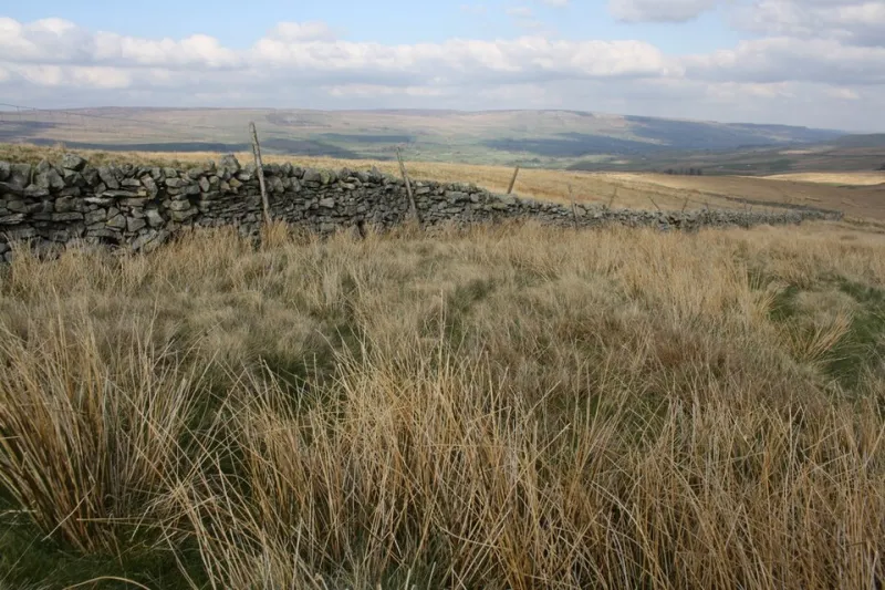
Photo: Roger Templeman , CC BY-SA 2.0, via Wikimedia Commons
In the US, a boundary often announces itself: a Forest Service sign, a cattle guard, a fence line on a map. In the high Andes, the message is quieter. A low wall of stacked stones runs uphill and then simply stops. A strand of wire crosses a trail at knee height. A patch of harvested potatoes is edged with dried stalks. None of it looks like a trailhead kiosk, but all of it is saying something.
That is the first thing to understand about land in the Andes: boundaries are not always built to keep you out. They are built to organize grazing, protect crops, mark a community’s edge, or keep animals from wandering into the next valley. The trick for a hiker is to read the sentence before crossing it.
A Wall Is Not Always a Wall
The stone walls you see above 12,000 feet are often less about exclusion than about work. They may hold soil, shelter a potato field from wind, separate a family’s animals from a neighbor’s, or mark the limit of a community’s pasture. Some are centuries old. Some were rebuilt last season. Many are only a foot or two high — enough to turn a sheep, not a person.
So do not treat every stone line as a hard no. Treat it as punctuation. Ask yourself what it is separating. If one side is dark, tilled earth and the other is open grass, you are probably looking at a crop boundary. If the wall follows a contour and the ground inside it is grazed short, it may be a livestock enclosure. If it runs between two drainages and there is no gate for miles, it may be a community limit.
The practical move is simple: do not step over a boundary just because you can. Walk parallel to it for a bit. Look for a gate, a gap, a worn path, or a person. In the Andes, the obvious route is often the one that has been used for generations, and it usually passes through a recognized opening.
Wire Tells a More Recent Story
Barbed wire and smooth wire fences are common in the high Andes, especially near roads and larger villages. They often mark land that has been divided, fenced, or claimed within living memory. A wire fence can mean a private field, a community pasture, or a boundary between two villages that do not agree about where the line should be.
When you meet wire across a trail, stop and look at the whole assembly. Is there a gate with a loop of rope? A stile made of stones? A gap where people clearly duck under? Is the wire rusty and loose, or tight and new? Is there a path on the other side that continues in the same direction?
If there is a gate, close it behind you. That sounds obvious, but in the Andes it is the kind of obvious that matters. A gate left open can put animals in the wrong field and put a farmer in a bad mood for the rest of the season. If there is no gate and no clear crossing, do not improvise a new one. Backtrack and look for the route the locals use.
Crop Markers Are a Different Language
In the US, we are used to trail signs that tell us where we are. In the Andes, many markers tell you what the ground is for. A field of quinoa may be marked with cloth strips or plastic bags. A potato field may be edged with a line of stones or a low earth berm. A pasture may be marked by a particular kind of grass or a fence made from brush.
These are not decorative. They are working boundaries, and they often change with the season. After harvest, a field may be open to grazing. Before planting, it may be closed. A route that was fine in June may cross a newly planted field in November. If you are hiking in the agricultural belt — say, between 11,000 and 13,500 feet — pay attention to what is growing and what has been recently turned over.
The safest rule is the one your grandfather probably told you: if it looks planted, it is planted. Walk around the edge. If there is a clear path through the stubble, use it. If there is not, do not make one.
Livestock Paths Are Not Hiking Trails
One of the most common mistakes independent hikers make in the Andes is following a well-worn path that turns out to be a cow path, a sheep track, or a route to a water source. These paths can be excellent — they go somewhere useful — but they often cut through private or community land without any formal right of way.
A livestock path usually has signs: hoofprints, droppings, clipped grass, and a width that feels more like a corridor than a trail. It may braid and fade. It may lead to a corral rather than a pass. If you follow one and it ends at a gate, a wall, or a field, that is the land telling you the path was not meant for through travel.
When in doubt, aim for the main trail. In the high Andes, main trails are often the ones that connect villages, markets, and passes. They may be rough, but they are usually recognized. If you are building a route from a map, assume that the straight line is wrong and the dotted line is probably a animal track.
Asking Permission Without the Performance
There is a fine line between asking permission and making a spectacle of yourself. In small Andean communities, a loud, formal request in broken Spanish can feel like a performance. A quieter approach works better.
Start with a greeting. Say good morning or good afternoon in Spanish, or in the local language if you know it. Ask if you can pass. Use simple words: “¿Se puede pasar?” — can one pass? — is usually enough. If there is a house nearby, approach it rather than standing at the fence and shouting. If no one is around, look for a clear trail and follow it, but do not assume silence is consent.
If someone says no, accept it. Do not negotiate, do not offer money, and do not explain that you have come a long way. A no is information. It tells you that the land is being used, that the route is not open, or that the person does not want strangers crossing. Turn around, backtrack, and find another way. The mountain will still be there tomorrow.
Plan Routes Like a Guest, Not a Claimant
When you plan a route in the high Andes, build in the possibility of a boundary. That means carrying a map that shows communities, not just trails. It means asking at the last village whether the route ahead is open. It means leaving a margin of daylight for a detour. And it means accepting that the shortest line on the map is often the one that crosses the most fences.
In the US, we are used to public land and legal access. In the Andes, access is often social. A trail may be open because people have always used it. A field may be closed because it is newly planted. A fence may be a suggestion or a hard limit, depending on the season and the person who built it.
The fence is a sentence. Read it before you cross it. And if you cannot read it, ask. That is not a sign of weakness on the trail. It is the whole point of traveling through someone else’s home.